Hazel Park, Michigan is located in the southeast corner of Oakland County. Sharing a border with the City of Detroit, Hazel Park is one of a number of "streetcar" suburbs that developed in the early years of the 1900s along the interurban lines that radiated out from Detroit. During a 20 year period, the population of Detroit exploded, adding over 1.1 million residents between 1910 and 1930, as workers flocked to work in the burgeoning automobile industry. The population growth spilled past the existing city limits into areas beyond the city. These areas, which were made up primarily of working farms, became the target of developers who sought to build new housing to serve new families moving to Detroit to work and those looking to escape the hustle and bustle of the city and the noise and pollution of the factories. As you can see in this map of the area around Detroit in 1905, there was a lot of open land between Detroit and the small village of Royal Oak.

Map of Detroit area in 1905
Courtesy of United States Geological Survey
One of the drivers of population growth north and west of the city was Henry Ford's decision to build his Ford plant in the Village of Highland Park, which sat astride a newly paved section of Woodward Avenue between Detroit and Royal Oak. The undeveloped areas around Highland Park were quickly annexed into the City of Detroit and subdivided in preparation for new homes. But the areas suitable for development were constrained to those areas closest to existing interurban lines and railroads.In the early 1900s, automobiles had just started to emerge as a common form of transportation. Most people, especially among the middle and working classes, didn't own a car and relied on rail-based transportation to get around in the city on street cars and on interurban cars (larger and faster than city streetcars) and passenger trains for travel between cities and villages. Areas that weren't within a reasonable walking distance to existing interurban lines were not considered desirable for development.
One such area was the southeastern corner of Oakland County which was part of Royal Oak Township. Most of the Township outside of the then Village of Royal Oak was made up of working farms. As demand for new homes boomed with the opening of the Ford plant in Highland Park, development quickly made its way north and west up Woodward Avenue into the southern portions of Royal Oak Township closest to the existing interurban line that ran along Woodward Avenue between Detroit and Pontiac. Areas in the path of this development soon developed into new communities including Ferndale and Pleasant Ridge. The Village of Royal Oak expanded in size and population. But areas more distant from the interurban line along Woodward Avenue weren't considered as suitable for development of homes.
One enterprising residential developer, Burnette Fechet Stephenson of Detroit, who went by his initials B.F., was undaunted by the prospect of the lack of access to interurban lines in this area. Working together with other prominent residential developers, Stephenson's group assembled over 1800 acres of farmland in the area between Highland Park and Royal Oak under the name of the Troy Oak Land Company (sometimes listed as the TroyOak Land Company). Stephenson, then announced that the "Highland Park and Royal Oak Railway" company would build an interurban line directly through the middle of their holdings from Highland Park into downtown Royal Oak along 4th Street as illustrated in this announcement by Stephenson in the Detroit Free Press. Newspaper articles noted that the principals of the new Railway company happened to be the same people heading up the Troy Oak Land Company.

Route of the Highland Park and Royal Oak Railway - March 31, 1916
Image courtesy of the Detroit Free Press
The announcement of the new interurban line didn't come without controversy. The Detroit United Railway, better know as the DUR, which operated the existing interurban line along Woodward initially objected to the new line. But ultimately, Stephenson and his group were able to convince the DUR to take over the proposed new line. Even though the line was eventually operated by the DUR, it was commonly known as the Stephenson line.
The construction and operation of the new line now assured, Stephenson and his associates quickly begin subdividing and improving the land along the route of the new interurban line and associated road, Oakland Avenue, that ran from Highland Park across 8 Mile into Oakland County and onward to Royal Oak as Oakland Boulevard. As the area filled with new residential and commercial developments, Hazel Park started to take on a distinct identity in this area of southeastern Oakland County helped in part by the presence of the Hazel Park School District which largely mirrored the boundaries of the current day City of Hazel Park. Although the area saw significant development before World War 2, the City of Hazel Park didn't incorporate until 1941.
My first encounter with B. F. Stephenson was while I was researching mortgage records in Oakland County. In March 1923, eight mortgages were filed on the same day, dated April 19, 1923, between B. F. Stephenson and Walker O. Lewis, trustee for Sears Roebuck. The mortgages ranged from amounts of $3,300 - $3,600, indicating that these were likely mortgages for houses in the middle of the price range for Sears houses (a Sears Vallonia in Royal Oak had a mortgage of $3,700 in September 1923).
After looking up the eight mortgages on microfilm, I discovered that two of the mortgages were located in the Nine Oakland Subdivision. This subdivision is located in present day Hazel Park. Using the lot numbers from the property descriptions in the mortgage records, I was able to find the current addresses for the houses using Oakland County's Property Gateway service. With addresses in hand, Google Streetview was able to provide me with a recent view of the houses. The first is at 68 West Robert and is this wonderfully maintained Sears Roseberry. This house has a reversed floor plan and the large bump out on the first floor for the kitchen is visible on the other side of the house as seen in the second photo.

Sears Roseberry - 68 West Robert, Hazel Park, Michigan
Image courtesy of Google Maps
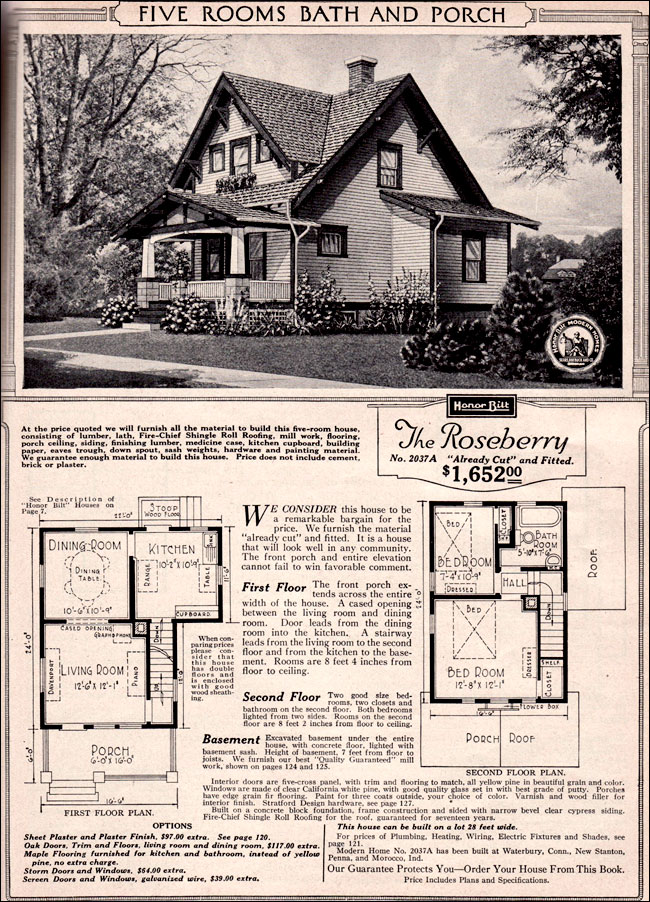
Catalog image of Sears Roseberry

Image courtesy of Bing Maps
The second house is a Sears Lebanon located at 119 West Otis. Although the catalog shows an exterior door from the kitchen on the side of the house, that's not present on this house.

Sears Lebanon - 119 West Otis, Hazel Park, Michigan
Image courtesy of Google Maps

Catalog image of Sears Lebanon
Image courtesy of Archive.org
Finding these houses was pretty exciting because they were the first example of either a Sears Lebanon or a Sears Roseberry that I had found in southeast Michigan. Both were popular models for Sears during the time period that they were offered but I haven't found them in the numbers that they've been found elsewhere in the country. Although there's no evidence to date showing how the materials for the homes arrived in Hazel Park, it's likely that the final leg of their travel was over the Stephenson interurban line. Although it's not commonly known, interurban lines were known to move freight. Did the Sears houses in Hazel Park arrive by interurban? Perhaps!
Now that I had found these 2 houses, I turned to the six remaining mortgages that were for six sequentially numbered lots in the Hazel Park Subdivision - lots 169 through 174, also located in Hazel Park. From the plat map of the subdivision, I could see that these houses were located on Otis Avenue, just a block from Oakland Boulevard, where the interurban line ran. It's unusual to see Sears houses grouped together like this in a single development. Did Stephenson order these as "model" homes to help sell the location to prospective buyers? Did he build these speculatively in the hopes of quickly filling them with new homeowners? Unfortunately, the records don't tell us the why but I was crossing my fingers that I was going to find 6 Sears houses in a row on Otis Avenue in Hazel Park.
And then this....

Lot view of lots 169 - 174 in Hazel Park, Michigan
Images courtesy of Oakland County Property Gateway
Not clear on what you're seeing? Here's a view zoomed out a bit.

Zoomed out view of lots 169 - 174 in Hazel Park, Michigan
Images courtesy of Oakland County Property Gateway
Sigh! To make the harsh reality clear, here's an aerial photo of those lots taken in 2014.

Aerial view of lots 169 - 174 in Hazel Park, Michigan - 2014
Images courtesy of Oakland County Property Gateway
Sadly, B.F. Stephenson's six Sears houses in a row are no more. Using the historical aerial photos available from Oakland County, we can see that the houses were there in 1963. I've marked the start and end of the group with red arrows. You can see that just south of this neighborhood, the road that started out as the Oakland Boulevard has been transformed into the 204 foot wide Stephenson Highway.

Aerial view of lots 169 - 174 in Hazel Park, Michigan - 1963
Images courtesy of Oakland County Property Gateway
Here's a zoomed in view of the houses showing a little more detail.

Zoomed in aerial view of lots 169 - 174 in Hazel Park, Michigan - 1963
Images courtesy of Oakland County Property Gateway
The fate of these houses is tied to the transformation of Oakland Boulevard from a local road into Stephenson Highway. The highway, which was named after B. F. Stephenson, embodied the "Superhighway" concept which had its origin in the 1920s as a solution to the increasing levels of automobile traffic on Detroit-area roads. Many area roadways were built or expanded following the "Superhighway" design which ranged from 150 feet wide to 204 feet wide including Eight Mile, Grand River, Gratiot Avenue, Northwestern Highway, Southfield, Telegraph and Woodward Avenue. Even as early as 1940, you can see the emergence of the Superhighway concept with Eight Mile and Woodward already widened to the Superhighway configuration and Stephenson widened north of Woodward Heights (half way between 9 and 10 Mile Roads) with vacant right-of-way south of that point.

Aerial view of Superhighways in Southeastern Oakland County - 1940
Images courtesy of Oakland County Property Gateway
The original Superhighway configuration was designed to accommodate interurban lines in the wide median between the paved lanes. In the case of the Stephenson line, the interurban line actually ran parallel to the north side of Oakland Boulevard. By 1963, the interurban tracks were nowhere to be seen and the roadway has been widened from its original 50 feet to 204 feet. Not long after the 1963 aerial photo was taken, Stephenson Highway itself would be largely replaced by the new I-75 freeway.
The construction of I-75 through Hazel Park in the 1960s was the demise of the Sears houses. As you can see from this aerial photo from 1974, the location of the houses, denoted with the red arrows, has been overtaken by the freeway service drive.

Aerial view of lots 169 - 174 in Hazel Park, Michigan - 1974
Images courtesy of Oakland County Property Gateway
It's not unheard of for houses to be moved out of the way of freeway construction. But to date, I haven't heard of any of these houses having been relocated. More likely, they were lost to the "wrecking ball" and consigned to the landfill of history. There's a bit of irony that the extra right-of-way that was necessary for the original "Stephenson" interurban line and that later facilitated the expansion of the "Stephenson" Highway provided the room (for the most part) to route the I-75 freeway through Hazel Park and in turn caused the loss of those six Sears houses.
It's always disappointing to find mortgage records for possible Sears houses that end up being lost to history, especially these homes that were directly tied to the history of Hazel Park. But that's offset by a little bit by the discovery that there are still some Sears kit houses in Hazel Park that can be tied back to B. F. Stephenson. For more about Stephenson's life after developing the interurban line and 5,000 home sites(!) along the line, read here. According to one of Stephenson's sons, Hazel Park the community was named after Burnette's second wife Hazel.
The suburbanization of Chicago is very similar to the Detroit story. The interurban electric rail lines (most of which are gone now) were a common way to ship the house kits. Today you can often find kit houses near what are now bike paths.
ReplyDeleteWeren't you going to try to ID the demolished houses from the aerial maps?? Come on--get on it!
I didn't want to take all of the fun out of it by trying to ID those myself!
DeleteVery interesting! Oh, the dismay when our mortgage leads go nowhere. Even sadder to really know for sure that the houses are gone, gone, gone.
ReplyDeleteGreat post, excellent research.
Judith
Sears-House-Seeker.blogspot.com
All true but the research has led me down some interesting paths!
DeleteThanks for your research! The photo above titled " Here It Is" is a great find. It answered the question as to WHY that S curve exists in I-75. He simply did not own the land. I need to do further research on the creation of Hazel Park, to verify the naming of the city for Stephenson's wife; Hazel.
ReplyDeleteI had fun doing it. Let me know if you find out "the rest of the story" when it comes to Hazel and the naming of Hazel Park.
ReplyDeleteSee this film. These are your houses?
ReplyDeletehttps://youtu.be/TfTqGTSOOkQ
Yes! The end house is a Sears Carlin. The house next to it is a Sears Marina. The third house from the end may be a Lebanon or a Marina - there's not enough of it shown in the video to know for sure. Thanks for sharing that!
DeleteAwesome research!
ReplyDeleteWhat a great blog!
ReplyDeleteWe live on West Otis, in the Lebanon model, since 1981.
ReplyDeleteVery cool! Thank you for sharing. Did you know it was originally from Sears?
Delete